The Story of the Inner Relief Road
Pam Wall


Before the Relief Road
At the start of the twentieth century, the Milford Street Bridge area’s streets were made of compacted earth and trampled by the hooves of horses. By 1912 an increase in traffic had put pressure on Salisbury’s roads, so the city bought its own machine to tarmac the roads.
Even by the 1920s congestion was a major problem. A traffic census in Milford Street in 1930 revealed that nearly a thousand cars, buses, lorries and vans passed along Milford Street every day. By the 1950s, the amount of traffic travelling through the streets had become a real problem – especially as it didn’t only have to contend with human pedestrians!
“Salisbury always had a tendency to get clogged up, what with the cattle and the traffic…...” (Anne Abrahams).
As Mrs M Tucker remembers:
Some people of course took advantage of the congestion:
Others had to find interesting ways to cross the road!
The coming of the Relief Road
To relieve the traffic congestion, in 1966 a City Traffic Plan was developed, of which the Inner Relief Road was just one part. It also involved the redevelopment of the city centre to include multi-storey car parks that were linked with elevated access roads and bridges.
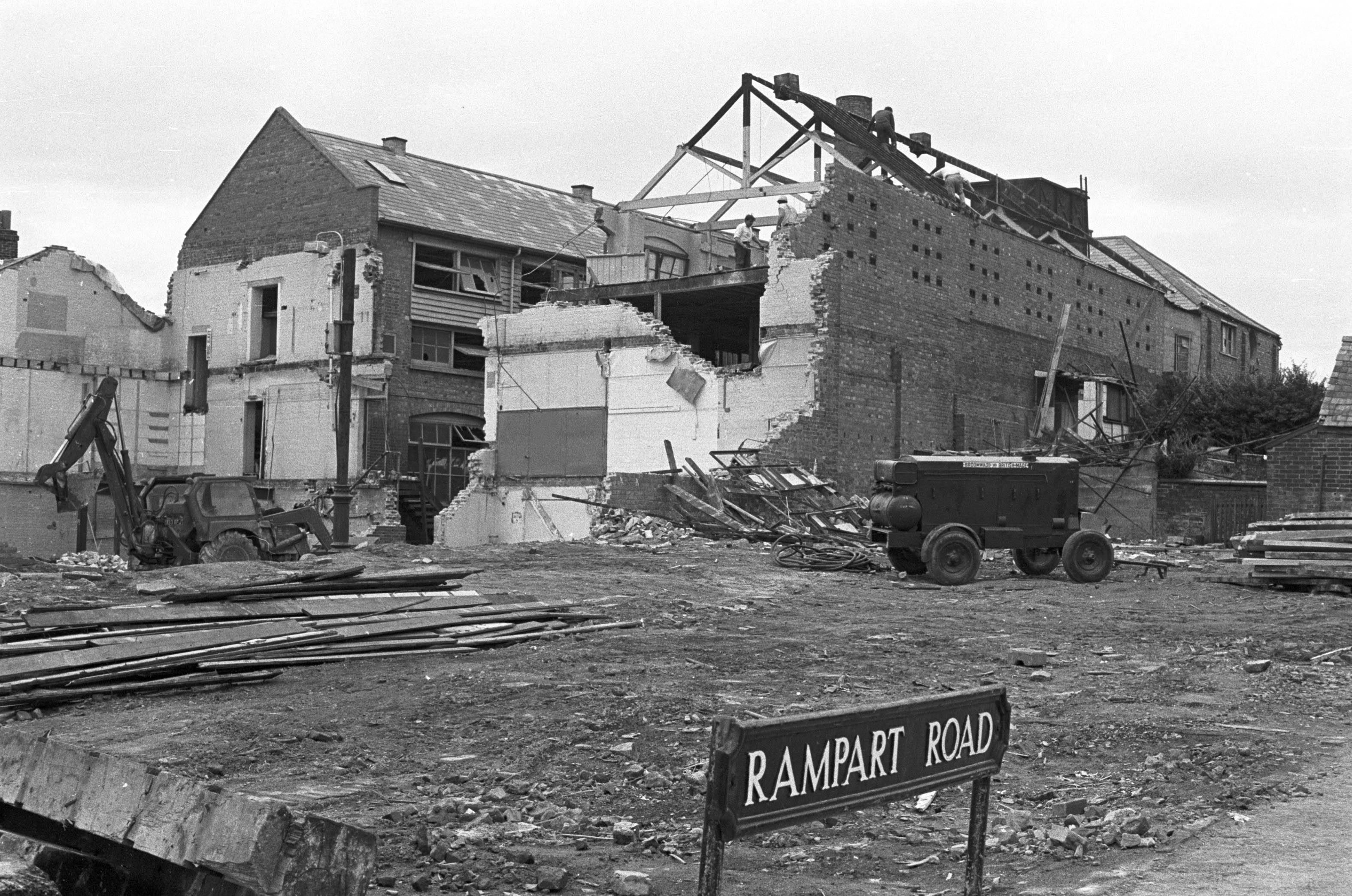
Stage 3 of the Inner Relief Road (Churchill Way East) from St Marks roundabout to the College roundabout, mainly follows the old route of London Road and Rampart Road. Permission for stage 3 was given after a Traffic Scheme Inquiry in October 1970.
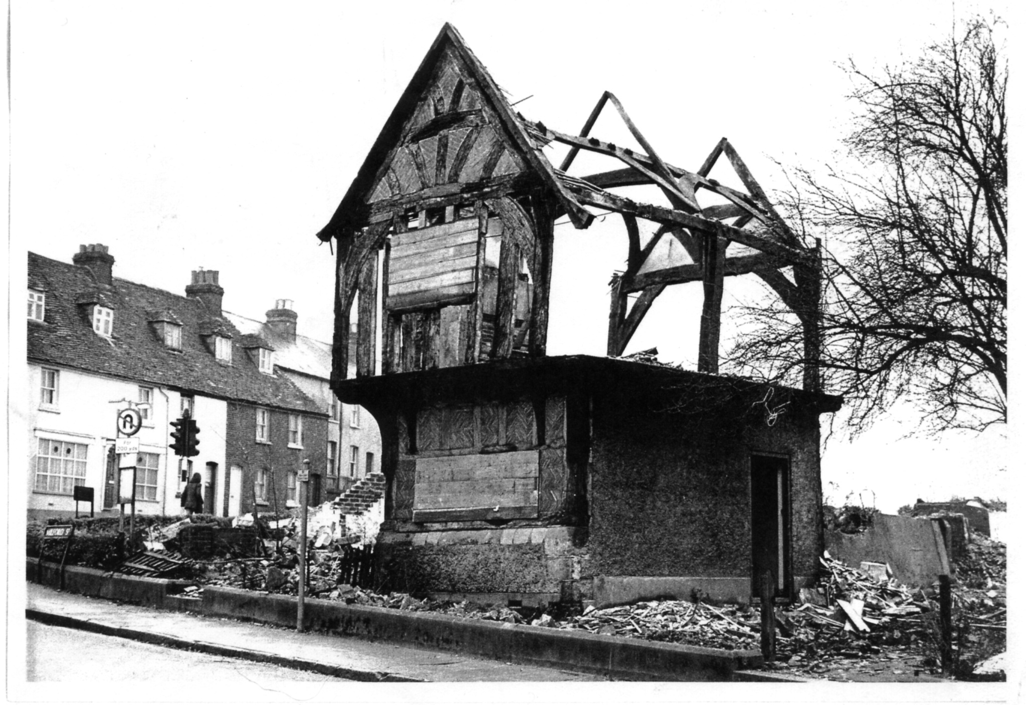
Preparations for the route included a number of buildings being demolished: houses on Rampart Road, Beckingsale Training Home for Girls at the end of St. Martin’s Church Street, Number 88 (the mediaeval hall) and other houses on Milford Street, the Almshouses at the top of Winchester Street, and the removal of a strip of land at the Greencroft. At the Inquiry it was mentioned that it was most unfortunate that the Relief Road had to encroach on the Greencroft but the alternative was that more people would lose their homes just to save roadside trees and a strip of open land.
Click on the audio bar, above right, to listen to what Phyllis Maple (pictured) had to say about this.
For many people there was great sadness –
“Well, it was quite a shake up when they brought that road, put that road through there because they pulled the house down my wife was born in. ‘Cause her family had to move elsewhere and, well we lost father and we lost mother and they moved to other properties, you know, old people’s homes and places like that. And, very often we’re going along that road, the old Rampart Road, the dual carriageway now, and just look across and think to myself that’s where the house was”. (Robert Fitzgeorge)
“When the road was going to go through then they took ‘alf my garden and my lovely apple tree they took, an’ all my gooseberry bushes, an’ I had twenty seven pound for that………. that was my compensation.” (Phyllis Maple of Guilder Lane)
“Well, originally, they were only go to take few houses, and our house and the next door house was supposed to remain, but then… the morning that my second son was born we had a letter to say that they needed our house as well, so where our house stood is now a rose garden”. (Doreen Gault, of St Ann St)
Rita Jacob had to move out of her childhood home on Rampart Road:
When Rita finally moved out:
For others, the building of the relief road seemed to happen overnight and made little difference:
The Road to Nowhere
However, the elevated access road running at a rooftop level was found to violate both the historic street plan and the predominately domestic nature of the adjacent buildings. For these reasons Salisbury District Council decided not to continue the road across to Brown Street.
Despite being defunct, the road to nowhere stood for several years, finally being demolished in the early 1980s. In the course of being built, it caused the demolition of several properties, and together with the car stack, split Culver Street in two.
Sue Morrissey, who grew up on Milford Street says:
Comments about this page
At the other end of the County in Calne, although the M4 was not long off opening the Highways planners order the destruction of about 12 shops, 13 homes, one pub, a school and an ornamental public garden plus an interesting building more than 200 years old. County Highways and the Ministry of Transport tried to sell it to the people of Calne that it was an improvement, rubbish, the new road they created tore the heart out of Calne but since when do planners care about people?,
Percy Churchfields dairy had to re-locate.
Add a comment about this page